加尔吉里亚山
-
远足
-
历史与文化
-
自然
-
宗教场所
描述
库鲁内格勒•西北省
山地/森林保护区
历史地标
自然与徒步旅行
山地/森林保护区
历史地标
自然与徒步旅行
概览:加尔吉里耶山 (ගල්ගිරියා කන්ද)
加尔吉里亚山 是一座孤立的山峰 库鲁内格勒区, 上升到 478米(1568英尺). 这是 西北省第七高峰 并位列第一 斯里兰卡第212高峰.
伸展 长度7公里, 与该地区其他孤立的山丘相比,加尔吉里亚山独具特色。如今,它被保护起来…… 森林保护区, 这里栖息着各种各样的动植物,使其成为斯里兰卡重要的自然和生态地标。.
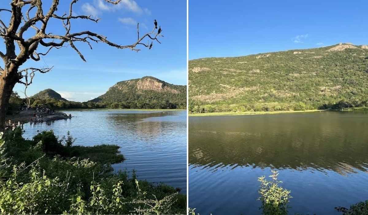
加尔吉里亚山 – 斯里兰卡库鲁内格勒区
历史
加尔吉里亚的历史可以追溯到……时代 杜图伽摩奴国王. 他的儿子,, 萨利亚王子, 他为了爱情放弃了王位,这在当时是众所周知的事。, 阿索卡马拉. 这对夫妇逃离了阿努拉德普勒,后来定居在加尔吉里亚附近。.
据信是萨利亚王子发起的。 水利 在该地区,山上的水资源被改造成水库,用于水稻种植。如今,附近还保留着六个水库: 库达·加拉维瓦、玛哈·加拉维瓦、恩博加马·维瓦、加克提亚加马·维瓦和卡杜鲁维瓦.
山的一端是 萨利亚隐修院, 保留了王子隐居的记忆以及他与这片土地的联系。.
特色与自然亮点
- 长度: 一条异常长的山脊(约 7 公里)。.
- 森林保护区: 这里拥有丰富的生物多样性,包括珍稀动植物。.
- 水源: 为附近对农业至关重要的水库和溪流供水。.
- 徒步潜力: 穿过森林小径,可欣赏全景。.
- 文化遗址: 与萨利亚王子有关的历史悠久的隐修院。.
简要信息
高度
478 米(1,568 英尺)
478 米(1,568 英尺)
省
西北
西北
区
库鲁内格勒
库鲁内格勒
长度
约7公里长的山脊
约7公里长的山脊
排行
在西北省排名第七
在西北省排名第七
历史遗址
萨利亚隐修院
萨利亚隐修院
附近油罐
库达·加拉维瓦、玛哈·加拉维瓦、恩博加马·维瓦
库达·加拉维瓦、玛哈·加拉维瓦、恩博加马·维瓦
受保护状态
森林保护区
森林保护区
到达目的地
加尔吉里亚山位于 库鲁内格勒区. 。 从 库鲁内格勒镇, 可通过连接恩博加马及周边村庄的当地公路抵达这座山峰。由于公共交通仅限于附近城镇,建议乘坐私家车或嘟嘟车前往。.
最佳旅游时间
游览加尔吉里亚山的最佳时间是…… 旱季(1月至4月,7月至9月). 清晨和傍晚气温较为凉爽,适合徒步和摄影。请避开10月至12月的大雨天气,因为此时步道可能湿滑。.
附近景点
- 库鲁内格勒岩(阿图加拉) ——一座标志性的岩石,上面有一尊佛像,俯瞰着整座城市。.
- 里迪维哈拉亚 – 康提壁画古石窟寺庙(约25公里)。.
- 库库勒加马和恩博加马水箱 与当地历史相关的灌溉湖泊。.
- 库鲁内格勒市 ——拥有殖民时期和文化地标的历史名城。.
常问问题
加尔吉里亚适合徒步旅行吗?
是的,这里有风景优美的步道和林间小径,但路况不一。请穿着合适的鞋子并携带饮用水。.
它的历史意义是什么?
与国王杜图伽摩努之子萨利亚王子有关,萨利亚王子为了爱情放弃了王位,定居在山附近。.
山周围有坦克吗?
是的,附近发现了六个坦克,据信是在萨利亚王子时期建造的。.
我需要获得许可才能参观吗?
无需特殊许可,但请尊重环境,因为这里是森林保护区。.
最佳旅游时间
-
全年
精彩片段
-
自行车停放处
-
免费入场
-
提供停车位
-
游览所需时间:1 小时
-
游览所需时间:半天
-
厕所可用