Rajanganaya è una zona storicamente ricca e agricolamente vivace situata nel Provincia centro-settentrionale dello Sri Lanka, rientrante nel Distretto di AnuradhapuraConosciuta per le sue terre fertili e l'iconica Bacino idrico di Rajanganaya, questa regione svolge un ruolo significativo nell'agricoltura basata sull'irrigazione dello Sri Lanka. Carro armato Rajanganaya, uno dei sistemi di irrigazione più antichi e grandi del Paese, sostiene migliaia di famiglie di agricoltori, rendendo l'area un centro per la coltivazione del riso e altre attività agricole. Per viaggiatori e ricercatori interessati allo sviluppo rurale o all'agricoltura sostenibile, Rajanganaya offre un perfetto connubio tra bellezza paesaggistica, stili di vita tradizionali e valore storico.
Dal punto di vista amministrativo, Rajanganaya è suddivisa in più Divisioni Grama Niladhari (GN), ciascuna con un codice GN univoco e nomi ufficiali in inglese, singalese e tamil. Queste divisioni GN aiutano a gestire i servizi pubblici, distribuire le risorse governative e supportare la pianificazione regionale. Avere accesso a un elenco strutturato e aggiornato di Codici GN a Rajanganaya è essenziale per chiunque sia coinvolto nella governance, nel settore immobiliare, nello sviluppo locale o nella fornitura di servizi basati sulla posizione geografica in Sri Lanka.
Popolazione totale
35.500–36.200
Divisioni GN
21
🌾 Perché Rajanganaya – Sri Lanka è speciale?
Dove le antiche acque alimentano un fiorente cuore agricolo
Situato nel margine occidentale del Distretto di Anuradhapura, Rajanganaya è un silenzioso centro nevralgico dell'agricoltura delle zone aride dello Sri Lanka. Confinante con il famoso bacino idrico di Kala Wewa e ricca di storia coloniale e di antichi geni dell'irrigazione, Rajanganaya offre una prospettiva unica sul duraturo rapporto del Paese con l'acqua, la terra e la comunità.
🚜 Costruito sull'acqua e sulla saggezza
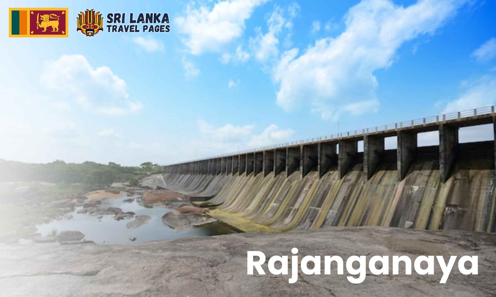
Al centro della vitalità di Rajanganaya risiede il Bacino idrico di Rajanganaya, un'estensione dell'antico sistema di Kala Wewa. Questo vasto specchio d'acqua continua a nutrire centinaia di chilometri quadrati di risaie e coltivazioni di chena. L'alba qui è dorata, proiettando riflessi su canali, bufali d'acqua e germogli di riso ricoperti di rugiada. Il canto degli uccelli si fonde con il ronzio ritmico delle ruote idrauliche, mostrando lo Sri Lanka rurale nella sua forma più autentica.
🏛️ Un capitolo nascosto della storia
Sebbene meno visitata dei siti storici limitrofi, Rajanganaya non è estranea al patrimonio culturale. Un tempo, l'area era vitale per gli antichi sistemi di irrigazione e insediamento legati al Regno di Anuradhapura. Oggi, queste eredità rivivono nei canali rivestiti in pietra, negli antichi bacini di contenimento delle cisterne e negli antichi rituali di coltivazione ancora praticati dagli agricoltori locali.
🍲 Piatti semplici, tradizioni ricche
A Rajanganaya, il cibo è sia sostentamento che cerimonia. Dai caldi string hoppers con kiri hodi nelle bancarelle lungo la strada ai sostanziosi piatti a base di riso e curry sotto gli alberi di mango, troverete sapori intrisi di amore e prodotti locali. Non dimenticate di provare il fresco cagliata di bufala abbinato alla melassa, una prelibatezza regionale.
🤝 Una comunità strettamente intrecciata
Lo spirito comunitario scorre forte quanto i canali di irrigazione. Che tu visiti durante il stagione del Vesak, UN giorno di pola (mercato)o a una funzione in un tempio locale, sarete accolti con calore. I bambini salutano dai trattori, gli anziani raccontano storie antiche e i visitatori sono spesso trattati come membri della famiglia: un segno distintivo dell'ospitalità di Rajanganaya.
🌱 Il progresso rurale incontra l'orgoglio culturale
Rajanganaya si sta evolvendo. Guidato dai giovani iniziative di agricoltura biologica, piloti di irrigazione a goccia, e modelli di agricoltura ecologica stanno mettendo radici. La regione sta ottenendo riconoscimenti per il suo equilibrio tra agricoltura sostenibile e orgoglio culturale. È un luogo in cui l'innovazione rispetta la tradizione, ideale per ecoturisti, ricercatori, e viaggiatori lenti alla ricerca di un'esplorazione guidata da uno scopo.
| Codice GN | Nome |
|---|---|
| 005 | Traccia 13 – 18 |
| 010 | Traccia 16 – 17 |
| 015 | Veheragala |
| 020 | Traccia 12 |
| 025 | Thulana Traccia 9 – 10 |
| 030 | Traccia 11 |
| 035 | Traccia 15 |
| 040 | Gemunupura |
| 045 | Traccia 07 |
| 050 | Thumbullegama |
| 055 | Randenigama |
| 060 | Traccia 4 |
| 065 | Traccia 3 |
| 070 | Naigala |
| 075 | Thissapura |
| 080 | Maha Thibrikalla |
| 085 | Angamuwa |
| 090 | 4 1/2 Kanuwa |
| 095 | Sirimapura |
| 100 | Pantiyawa |
| 105 | Kalundegama |
| Anno | Popolazione stimata |
|---|---|
| 2012 | 33,543 (attuale) |
| 2019 | ~36,100 |
| 2023 | ~35,600 |
| 2024 | ~35.500–36.200 |
- Stazione di polizia: 025-3891500/ 071-8591220
- Ospedale: 0252 276 462 / 0253 858 182
Periodo migliore per visitare Rajanganaya
Rajanganaya, situata nella provincia centro-settentrionale dello Sri Lanka, gode di un clima tipicamente secco, caratterizzato da lunghe giornate di sole, piogge stagionali e un intenso ritmo agricolo. Sebbene la zona sia accessibile tutto l'anno, il periodo migliore per visitare Rajanganaya va da dicembre a marzo, quando il cielo è terso, l'aria è più fresca e la bellezza naturale di questo cuore agricolo è al suo apice.
🌞 La beatitudine della stagione secca (dicembre-marzo)
In questi mesi, Rajanganaya risplende con campi rigogliosi, laghi tranquilli e accoglienti paesaggi rurali. È il periodo ideale per gite panoramiche in bicicletta intorno al bacino di Rajanganaya, per osservare gli uccelli lungo i canali di irrigazione o semplicemente per gustare piatti locali all'ombra degli alberi. La stagione secca rende anche più facile esplorare i vicini luoghi di interesse culturale e storico come Kala Wewa e la statua del Buddha Avukana.
🌧️ Magia della stagione Maha (ottobre-gennaio)
Nonostante la pioggia, il monsone Maha porta vita alla terra. I bacini idrici si riempiono d'acqua, inizia la semina del riso e il paesaggio si trasforma in una lussureggiante distesa verde. Questo è il periodo migliore per eco-viaggiatori e fotografi per catturare il ritmo autentico della vita nei villaggi dello Sri Lanka. Osservare i contadini lavorare nei campi e le mandrie di bufali al fresco nei wewas crea momenti indimenticabili.
🌾 Serenità rurale tutto l'anno
Anche durante la stagione di Yala (da maggio ad agosto), Rajanganaya offre un fascino tranquillo. Le mattine sono tranquille e ideali per passeggiate nei villaggi, mentre la sera si illumina il tramonto sulle cisterne. Con meno folla e giornate più tranquille, questo periodo è perfetto per i viaggiatori in cerca di relax e autentici contatti con la gente del posto.
Che siate attratti dalla cultura, dalle tradizioni agricole o dal lento ritmo del villaggio, Rajanganaya offre una fuga significativa in ogni stagione.
Come raggiungere Rajanganaya
Rajanganaya, una tranquilla cittadina agricola nella provincia centro-settentrionale dello Sri Lanka, è nota per il suo enorme bacino idrico e la sua ricca cultura agricola. Situata vicino a Kala Wewa e Avukana, è raggiungibile sia tramite strade che tramite i trasporti regionali. Che proveniate da Colombo, Anuradhapura o Dambulla, questa guida vi aiuterà a esplorare opzioni di viaggio, distanze e suggerimenti di percorso per raggiungere Rajanganaya senza problemi.
| Città | Distanza | Tempo stimato | Informazioni sul percorso |
|---|---|---|---|
| Colombo | 180 chilometri | 4,5 – 5,5 ore | |
| Anuradhapura | 50 km | 1 ora | |
| Dambulla | 60 chilometri | 1,5 ore | |
| Kurunegala | 100 chilometri | 2,5 ore | |
| Galnewa | 20 chilometri | 25 minuti |
📍 Mappa interattiva del percorso
Panoramica geografica – Rajanganaya
- Provincia: Provincia Centro-Settentrionale
- Distretto: Anuradhapura
- Segreteria divisionale: Segreteria divisionale Rajanganaya
- Aree vicine: Kala Wewa, Thambuttegama, Galnewa, Medawachchiya
Rajanganaya è una pittoresca regione agricola situata nel cuore della zona arida dello Sri Lanka. Situata al confine occidentale del distretto di Anuradhapura, fa parte del vitale corridoio di irrigazione alimentato dall'antica cisterna di Kala Wewa e dalle sue estensioni. L'iconico bacino idrico di Rajanganaya, costruito a metà del XX secolo, è uno dei più grandi e importanti progetti di irrigazione moderni dello Sri Lanka, svolgendo un ruolo centrale nella coltivazione del riso e nella gestione delle risorse idriche in tutta la regione.
Il territorio di Rajanganaya è prevalentemente pianeggiante e fertile, intervallato da canali, risaie e terreni coltivati a chena. Il suo ecosistema prospera grazie alle precipitazioni stagionali dei monsoni di Maha e Yala, rendendolo ideale per riso, ortaggi e altre colture erbacee. L'area è inoltre punteggiata da cisterne (wewas), piccole foreste e insediamenti rurali, che le conferiscono un fascino rurale tranquillo e pittoresco.
La sua vicinanza a monumenti storici come la statua del Buddha di Avukana, Kala Wewa e la Città Sacra di Anuradhapura rende Rajanganaya un gioiello nascosto per il turismo culturale ed ecologico. La zona sta inoltre guadagnando riconoscimento per le sue innovazioni di base nell'agricoltura biologica e nei progetti di sostenibilità rurale.
Che siate interessati all'agricoltura, al patrimonio culturale o alla vita in comunità, Rajanganaya offre un mix unico di bellezza naturale e progresso mirato.
Economia e agricoltura locale – Rajanganaya
Rajanganaya prospera come una delle regioni più produttive dal punto di vista agricolo dello Sri Lanka, ancorata al suo vasto bacino idrico e al ricco patrimonio agricolo. Situato nel zona secca della provincia centro-settentrionale, l'economia locale è guidata da coltivazione del riso, che domina il paesaggio grazie all'estesa Bacino idrico di Rajanganaya—una moderna meraviglia ingegneristica costruita per soddisfare le esigenze di irrigazione di migliaia di famiglie di agricoltori.
Oltre al riso, colture commerciali Piace peperoncino, mais, fagiolo dall'occhio e fagiolo verde sono coltivati sia su terreni irrigati che su terreni chena (taglia e brucia). Queste colture diversificate non solo sostengono il consumo familiare, ma contribuiscono anche alla filiera dell'agricoltura commerciale attraverso centri di raccolta regionali e la raccolta settimanale pola (mercato).
Coltivazione di Chena continua a essere praticato da molti piccoli agricoltori che vivono vicino alle riserve forestali, combinando tecniche antiche con i cicli stagionali. Questo modello sostenibile sostiene la biodiversità e garantisce la sicurezza alimentare anche in condizioni climatiche difficili.
Al di fuori dell'agricoltura tradizionale, industrie artigianali e imprese rurali come la ceramica, la lavorazione alimentare, la produzione di prodotti in fibra di cocco e l'allevamento del bestiame sono fonti di reddito emergenti. Il governo e le ONG forniscono supporto attraverso programmi di microfinanza, organizzazioni di agricoltori e società cooperative, consentendo l'emancipazione economica soprattutto delle donne e dei giovani.
Recentemente, eco-agricoltura e agriturismo Le iniziative hanno iniziato a prendere piede a Rajanganaya, consentendo ai viaggiatori di sperimentare l'autentica vita di villaggio, contribuendo direttamente all'economia locale. Con il suo equilibrio tra tradizione e innovazione, Rajanganaya si pone come un modello di sviluppo economico resiliente e basato sulla comunità.
Comunità e Cultura – Rajanganaya
Rajanganaya, una città rurale molto unita nello Sri Lanka Provincia Centro-Nord, ospita prevalentemente comunità buddista singalese Radicata nella tradizione, nella semplicità e nell'armonia collettiva, la vita a Rajanganaya ruota attorno ai templi del villaggio, alle risaie e ai canali di irrigazione ininterrotti che sostengono sia la terra che lo spirito della sua gente.
I templi della città, spesso situati accanto ad antichi canali o su tranquille colline, servono sia come santuari spirituali e centri culturaliQui, gli abitanti del villaggio si riuniscono per i rituali quotidiani, la scuola domenicale del Dhamma e le osservanze stagionali. I monaci svolgono un ruolo fondamentale nel guidare i giovani su valori come rispetto, generosità e consapevolezza, creando un forte legame intergenerazionale nella comunità.
Festival come Vesak, Poson, e Nikini Poya vengono celebrati con sincera devozione. Gli abitanti del villaggio accendono lampade a olio, costruiscono lanterne artigianali e organizzano Dansalas (bancarelle di cibo gratuito) per servire pellegrini e viaggiatori. I canti pirith che durano tutta la notte, le rappresentazioni teatrali nei templi e le processioni tradizionali mettono in risalto il profondo ritmo spirituale che definisce l'identità di Rajanganaya.
La cultura locale è ulteriormente preservata attraverso rituali popolari, danze tradizionali e tamburi, soprattutto durante le perahera nei templi e le serate culturali nelle scuole dei villaggi. Questi eventi riuniscono artigiani, anziani e bambini in una vivace dimostrazione di orgoglio comunitario.
Ciò che rende Rajanganaya speciale è il suo ospitalità incrollabileChe tu visiti una casa, partecipi a un festival o semplicemente passi attraverso il pola (mercato settimanale), sarai accolto con gentilezza, una tazza di tè e storie tramandate di generazione in generazione, rendendolo un vero cuore di Cultura rurale dello Sri Lanka.
Istruzione e strutture pubbliche – Rajanganaya
Rajanganaya, pur essendo principalmente noto per la sua forza agricola, offre anche elementi essenziali servizi educativi e pubblici che sostengono lo sviluppo e il benessere della regione. Come cuore rurale nel Distretto di Anuradhapura, le sue scuole e i suoi centri di assistenza svolgono un ruolo cruciale nell'emancipazione dei giovani e nel garantire l'accesso ai servizi essenziali per la comunità in generale.
La zona ospita diverse scuole pubbliche tra cui Rajanganaya Central College e Maha Vidyalaya basati su trattati, che forniscono istruzione di livello primario e avanzato ai bambini dei villaggi circostanti. Queste istituzioni servono anche come centri per sport, formazione alla leadership e sviluppo culturale, formando le future generazioni di studiosi e professionisti rurali.
Per integrare l'istruzione formale, scuole materne, lezioni private, e programmi di formazione professionale si occupano dell'educazione della prima infanzia e dello sviluppo delle competenze per i ragazzi che lasciano la scuola. Basato sulla comunità laboratori informatici, spesso introdotti attraverso progetti di sviluppo provinciali, contribuiscono a ridurre il divario digitale rurale e offrono agli studenti l'accesso a moderni strumenti di apprendimento.
L'assistenza sanitaria a Rajanganaya è basata su Ospedali divisionali situato in Tratto 05 e Tratto 11, offrendo servizi in assistenza materna, medicina generale e trattamento ambulatorialeInoltre, Dispensari ayurvedici fornire cure tradizionali, integrando gli approcci medici moderni per un'assistenza olistica alla comunità.
La città è servita anche da un stazione di polizia, ufficio postale, centro di servizi agrari, Banca Samurdhi, e punti vendita cooperativi — garantire l'accesso alla sicurezza, alla comunicazione, agli aiuti finanziari e ai servizi legati all'agricoltura. Locale linee di autobus collegare Rajanganaya ad Anuradhapura, Kala Wewa e Dambulla, migliorando la mobilità dei residenti.
Insieme, questi istruzione e strutture pubbliche creare un sistema di supporto resiliente, che sostenga la comunità di Rajanganaya e promuova uno sviluppo rurale inclusivo.
Trasporti e accessibilità – Rajanganaya
Rajanganaya, situato nel Distretto di Anuradhapura dello Sri Lanka Provincia Centro-Nord, è moderatamente accessibile e continua a migliorare la sua connettività attraverso lo sviluppo delle infrastrutture rurali. Pur non trovandosi su una grande autostrada o linea ferroviaria, Rajanganaya è strategicamente collegata alle città vicine come Thambuttegama, Kala Wewa, Anuradhapura, e Dambulla tramite strade regionali.
La principale via di accesso a Rajanganaya è attraverso la Strada Thambuttegama-Rajanganaya, che collega al Autostrada A12 (percorso Puttalam-Trincomalee). Da Colombo, i viaggiatori possono prendere le autostrade A6 o A28 per Thambuttegama e poi raggiungere Rajanganaya con un breve tragitto in auto di circa 12–15 chilometri.
Sebbene Rajanganaya non abbia una propria stazione ferroviaria, Stazione ferroviaria di Thambuttegama—situato a soli 20-25 minuti di distanza—serve come collegamento ferroviario più vicino sulla Linea del Nord, offrendo collegamenti ferroviari per Colombo, Jaffna, Kankesanthurai, e Vavuniya.
Servizi di autobus pubblici sono spesso disponibili da Thambuttegama, Anuradhapura e Galnewa a Rajanganaya. IL Stazione degli autobus di Rajanganaya, situato vicino al centro cittadino, funge da mini punto di transito per pendolari, studenti e agricoltori che trasportano prodotti agricoli.
Per gli spostamenti locali, i residenti utilizzano veicoli a tre ruote (tuk-tuk), motociclette, e biciclette, soprattutto quando si attraversano divisioni GN, canali di irrigazione o zone agricole. Durante le festività o gli eventi comunitari, spesso vengono noleggiati furgoni e camion privati per il trasporto di gruppi.
Grazie alla sua crescente rete di strade rurali e trasporto pubblico, Rajanganaya sta diventando sempre più accessibile, supportando entrambi commercio agricolo e mobilità regionale nella zona arida centrale dello Sri Lanka.
📸 Perché visitare o investire a Rajanganaya
Rajanganaya offre un mix unico di terreni agricoli fertili, innovazione guidata dalla comunità e un ambiente sereno, ideale per investimenti in agricoltura, turismo e sviluppo rurale.
- 💧 Patrimonio irriguo: Circondata dal bacino idrico di Rajanganaya e dal sistema di Kala Wewa, la zona è un modello di irrigazione moderna legata all'ingegneria antica.
- 🌾 Potenziale agro-basato: Nota per la coltivazione di riso, mais e fagioli verdi, Rajanganaya è il luogo ideale per l'agricoltura ecologica e gli investimenti sostenibili.
- 🛣️ Connettività emergente: Raggiungibile tramite Thambuttegama e collegata a Dambulla e Anuradhapura, Rajanganaya sta diventando un'importante porta d'accesso all'entroterra.
Che siate amanti della natura, agricoltori o esploratori culturali, Rajanganaya vi accoglie a braccia aperte e con un potenziale illimitato.