fbpx

Things to See & Do near Badulla

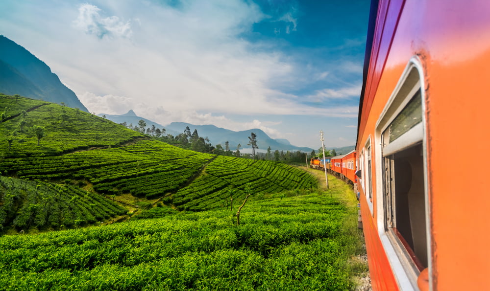
Badulla is the centre of Uva Province in Sri Lanka. The Namunukula range of mountains overshadows the town. Badulla is about 230km distant from Colombo towards the eastern hills of the central mountains of Sri Lanka.

Dunhinda waterFall

The 63m high Dunhinda Falls is undoubtedly one of the most glorious waterfalls in Sri Lanka. The beauty of the fall and the surrounding nature has made it one of the highest-ranked tourist attraction places in the country. Dunhinda Falls has located about 5km to the north of Badulla City and originated from the adult Oya. The name “Dunhinda” in Sinhala refers to smoke as it produces a cloud of smoke when the water cascades into a large pool on the ground.
To reach the waterfall, you have to walk about 1.5kms from the entrance gate. The Walk towards Dunhinda itself is a fascinating experience to sight wild birds, butterflies, monkeys, Deer in their natural habitat.

Muthiyangana Raja Maha Viharaya

Muthiyangana Raja Maha Viharaya lies amidst the city of Badulla. Muthiyangayana Chethiya is the seventh of the sixteen sacred places in Sri Lanka.
At the invitation of Naga King Maniakkika, Lord Buddha has visited the island for the third time along with 500 other thero to Kelaniya. On the same visit, Buddha has also come to Badulla, accepting the invitation of King Indika, who was the ruler of Namunukula mountain Range at the time. The king has built a stupa enshrining some hair and mukthaka Dathu (drops of sweat turned into pearls) of Buddha on the location where Buddha made his sermons in the Badulla district. This stupa and the temple has been developed, reconstructed and renovated by many kings throughout the next 2500 years. Accordingly, in the 3rd century B.C, King Devanampiyathissa has enshrined "Sarwachna Dathun" and rebuilt the Muthiyangana Stupa. Likewise, King Jettathissa has expanded the stupa during his reign. It is also written in several historic encryptions that King Rajasinghe the second has renovated the temple, which had been destroyed due to attacks from enemies.
You will come across a 'Thorana' at the door to the temple, which has a unique perspective with six levels. You will come across the main image house as you enter the temple. At The entry is a colourful 'Makara Thorana'. And right above the door and below the dragon head is a figure of Maithee Bodhisattva. Crossing the image house, you come to the perfect structure of the temple, the stupa. Back in the main image, the house is another image house identified as the centre image house (Mada Vihara Ge).

Bogoda wooden bridge

Bogoda wooden bridge is an ancient bridge situated in the Badulla district, close to Hali Ella town. It can also be named the oldest wooden bridge in the country, which belongs to the era of the Dambadeniya kingdom (1220–1345 AD).
The bridge was initially built with wood without using any iron nails.
The bridge is built above the Loggal Oya, next to the Bogoda Temple. According to the myths, the old Badulla – Kandy road was utilised by the early Sinhalese kingdom’s era.
Moreover, there is an old tunnel you can see at the premises of Bogoda Temple. Even though it is not available for more than a few meters today, according to the villages, the other end of that tunnel can be seen about 12 km distant from that point.

Old Dutch Fort

Old Welekade Market, previously known as Badulla Dutch fort, is situated in the district of Badulla. It is near Badulla-Bandarwela road. The distance from Ella to Old Welekade Market is just 21.6 km which is just a 40-minute long ride.
It has been a protected building since June 06th, 2008. The Archaeological Department of Sri Lanka presently controls the building. This place was utilized as a castle or fortress by the Dutch, while others say it was built by the British in 1889.
It is recognized as one of the acts done in the Badulla district after the British signed the Kandyan Convention with Sri Lankan heads in 1818. It consists of British-style wooden arches, which can be seen up to date, and it also consists of a high central roof and a lower roof with four entrances. In the inner space, there is an octagonal primary compound and four cross-shaped yards. Another building was built in the shape of crosses; this is done to maintain the archeological and architectural values.

Narangala Mountain Range

Narangala Mountain Range is one of the major tourist attractions in the Badulla district due to its cultural and environmental consequences. The magnificent 360-degree view from the mountain's peak has made Narangala renowned among locals and tourists for hiking and camping. The cold breeze and the misty weather in the area make it an ideal location for night campers. It is rising to approx. One thousand five hundred meters, it's the second-highest peak in the Uva Province, only second to the Namunukula Mountain range. The unique rectangular-shaped plateau and the triangular-shaped peak makes Narangala stand apart from the other mountains in the area. It is placed at the edge of Uva while pointing out a gap formed between the valleys of Uma Oya, Bandulu Oya and Loggal Oya. This gap opens up a comprehensive view of the Mahaweli flood plains, which extends up to Trincomalee. According to Folklore, back in the day, king Walagamba had hidden nine pots of gold that belonged to him inside a cave in the mountain during his reign in the country, due to which the name "NawaRanKala" (Nine Gold Pots) was given to this mountain range. Later, it was transformed to "Narangala". It is also addressed as "Thanga Malai" in Tamil, which translates to the "Golden Mountain" for the scenic golden grassland that blankets the mountain's slope.

Peessa Ella Waterfall

Peessa Ella Waterfall is enchanting and one of several in the Badulla, Uva region. This 45m raised Peessa Ella waterfall is not generally known and is created from an aquifer at the top of Lunugala Mountain. Besides, the water moves into the Kurakkan Oya, which runs over Madolsima. When it rains, the extra volume of water makes Peessa Falls waterfall into two streams.
Peessa Ella Fall is the so-called ‘peessa’ in old Sinhala, which refers to people gathering. It is assumed that it was here that King Dutugamunu organised workers to build religious buildings. The 5km Peessa Canal irrigates about 20 hectares of land in the farming community all year round. The starting point of the canal follows a minor fall.

Also Read

Leave a Reply

Your email address will not be published. Required fields are marked *


 / 

Sign in

Send Message

My favorites